Search Collections
- Object[355]
- yes[355]
- no[355]
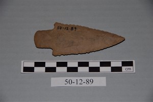
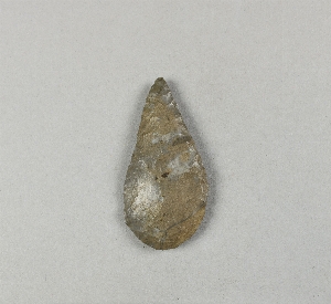
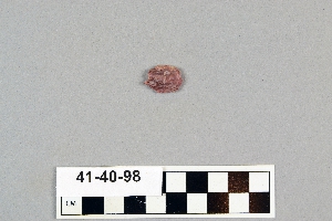
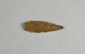
- point[355]
- alabama[2]
- albany county[1]
- anderson lake[15]
- apache canyon[3]
- arizona[3]
- arkansas[28]
- auburn[2]
- bailey county[1]
- bainbridge (pennsylvania)[2]
- beck forest lake[19]
- berks county[3]
- big timber creek[10]
- bucks county[34]
- chester county[6]
- chickies[1]
- clarksboro[3]
- clovis[52]
- colorado[2]
- columbia (pennsylvania)[2]
- delaware[1]
- duboistown[3]
- east greenwich township[3]
- east tennessee[4]
- eastern united states[3]
- eddy county[1]
- europe[1]
- florence (texas)[3]
- florida[1]
- fremont railroad[1]
- garrett[2]
- georgetown[29]
- gloucester county[14]
- gravel pit[11]
- hans hoch's fields[1]
- harding county[7]
- henry gault mound[3]
- jenkins[2]
- juniata county[1]
- lake[5]
- lancaster county (pennsylvania)[38]
- lee county (alabama)[2]
- leon county[1]
- lewisburg[1]
- lewisburg region[4]
- live oak peninsula[7]
- locust grove[6]
- loudonville[1]
- luzerne county[1]
- lycoming county[3]
- mercer county[1]
- miniosa draw[6]
- missouri[6]
- mora county[3]
- muerto creek[7]
- near bueyeros[7]
- near carlsbad[1]
- near dalhart[3]
- near levy[3]
- near nara visa[6]
- near pasamonte[1]
- near san jon[2]
- near taos[2]
- near tecolote[2]
- near tucumcari[2]
- new jersey[18]
- new mexico[79]
- new york[1]
- north carolina[1]
- northumberland county[3]
- oklahoma[1]
- oley[2]
- pechoqueolin creek[8]
- pennsylvania[113]
- philadelphia[12]
- philadelphia county[12]
- pot creek[2]
- pricetown[1]
- quay county[12]
- rattlesnake point[1]
- red fish point[1]
- red river[29]
- rincon[2]
- salinas creek[3]
- san miguel county[2]
- schuylkill county[1]
- southwestern arkansas[1]
- st. charles bay[2]
- summit station[1]
- susquehanna river[6]
- tallahassee[1]
- taos county[2]
- texas[93]
- trenton[1]
- troutman ranch[2]
- union county (pennsylvania)[5]
- united states of america[275]
- utah[2]
- washington boro[23]
- wiley[1]
- williamson county (texas)[29]
- choctaw[1]
- mousterian[1]
- pueblo[1]
- blow-out[1]
- bottom layer, 5 ft. deep.[1]
- bottom level.[1]
- camp site[2]
- embedded in sand[1]
- first terrace surface[2]
- found near mammoth bone[1]
- from lake 3 mi. w. of gravel pit near clovis, n.m.[1]
- from top layer of mound.[1]
- just above mammoth tusk[1]
- lake 15 mi. west[2]
- near hearth[1]
- near mammoth tusk[1]
- river bank[4]
- sand "blowout" 20-25 miles northeast of carlsbad[1]
- surface[7]
- surface in blown area[3]
- west side of gravel pit[1]
- chipped[180]
1 - 32 of 355 Records